


The Crossing of the Three Refuges is a fantastic proposal to discover, on foot, unforgettable places in the Eastern Pyrenees.
You will enjoy the abundance of wildlife, beautiful flowers, spectacular gorges, secluded lakes, lush forests and mighty rivers. At the end of each stage you will live the experience of living in guarded shelters where you can regain strength for the next day.
During the journey, there are more than 3,000 meters of unevenness up and down. Those with more strength can complete the days by climbing the most representative peaks in the area: Bastiments, Gra de Fajol, Gallinàs, Torreneules and Puigmal, thus accumulating a total of more than 6,000 meters of unevenness.
To complete the route, you must walk through the mountains for 3 to 6 days, spending the night in the Ull de Ter, Coma de Vaca and Carançà refuges.
- Cumulative climb - 3,000+ m
- Time - From 3 to 6 days.
- Difficulty - Medium - High
- Path - GR-11 and yellow stripes
- Departure point - Setcases
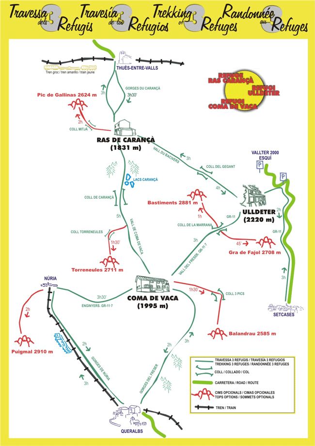
Next, we detail the stages of the route. Check the map of the journey here.
Setcases - Ulldeter's Refuge
Path marked with red and white stripes (GR-11). From the picturesque town of Setcases we will go up the Ter valley. When we arrive at Pla de la Molina, we will leave the Coma del Orri valley on our left. One kilometer from the Vallter 2000 ski resort, we will find a sign indicating the Ulldeter refuge. Following the path up and about 20 minutes later, we will arrive at the refuge where we will be rewarded with the beautiful view of the north face of the Gra de Fajol.
- Time: 3 hours
- Elevation gain: + 1000m.
Ulldeter Refuge - Ras de Carançà Refuge (Bacivers Valley)
From the Ulldeter refuge, we follow the red and white lines of the GR-11 to the Col de la Marrana. We leave the GR-11 and head north to find the pass between Pico de Bastiments and Pico de la Dona.
The view from the Collado del Gigante rewards us for the effort. We will leave the lonely lakes of Bacivers and go down the valley until we find the GR-10 (red and white stripes). In a few minutes, we will arrive at the bucolic place where the Ras de Carançà refuge is located.
- Time: 3 hours
- Elevation gain: + 400m, -800m.
AD · RUTES_RUTA · Slot: 3740555068
Ras de Carançà - Cow Coma
 From the Ras de Carançà refuge, we enter the forest to go up the Carançà river. Further on, we find the beautiful lakes of Carançà under the domain of Pico del Infierno. At the end of the valley we arrive at the Carançà pass where we will cross the GR-11 (red and white markings).
We continue south through a fairly straight lunchbox at its beginning. Now the path is marked with red dots. We go down the lonely valley of Coma de Vaca with the river on our right. At the end of the valley we reach the Freser river, where we find the Coma de Vaca refuge.
- Time: 5 hours
- Elevation gain: + 1000m., -800m.
Cow Coma - Ulldeter
Path marked with red and white stripes (GR-11.7). From the Coma de Vaca refuge, we will go up the bucolic Freser valley accompanied by marmots, chamois and other neighbors. When we reach the rain gauge, we will leave the bottom of the valley and go up the slopes to the east until we reach the Col de la Marrana. From this point we can see the Vallter 2000 ski resort below and the Canigó in the background. We will go down towards the east until we reach the Ulldeter refuge (GR-11).
- Time: 3 hours
- Elevation gain: + 500m, -300m
Source: Setcases Town Hall
AD · RUTES_RUTA · Slot: 3740555068
Nearby experiences
Exhibition "Música de tot cor. Joan Tomàs i Parés" in Queralbs
QueralbsThis summer, Queralbs will dedicate a cultural program to the town's musical memory and to the figure of Joan Tomàs i Parés, musician, folklorist and collector of popular Catalan songs. The events will begin on Wednesday, July…
Activities and experiences in Ripollès
Ripollès TurismeReal experiences and authentic emotions. That's what awaits you in Ripollès, where you'll find everything you need to connect with the essence of the region. There are options for all ages and to enjoy year-round. Families, couples,…
Nearby routes
Tour of the Carboner River in Setcases
Setcases
Itinerary that runs through high mountain forests where abundant fauna lives, from which we can detect traces. We will have fantastic views over the Ter and Carboner valleys. Route with a lot of contrast: first we follow the Carboner river;…
Road from Queralbs to Núria by Daió
Queralbs
The Queralbs path in the Núria sanctuary is one of the most classic walks in the Ribes Valley and it will take us through a charming valley, with several waterfalls and spectacular cliffs, with the final reward of reaching Nuria. Difficulty:…
Walking through the Valley of Camprodon
Camprodon, Llanars, Sant Pau de Segúries, Setcases, Vilallonga de Ter
Located in the eastern part of the region of Ripollès, Camprodon Valley is located in border area of the neighboring country, France. Formed by only six municipalities, although scattered grouping several cores, is crowned by a ski slope,…
Related routes
Paths of the Bishop and Abbot Oliba
Artés, Casserres, Folgueroles, L'Estany, L’Esquirol, Manresa, Navarcles, Olesa de Montserrat, Sant Pere de Torelló, Santa Maria de Besora, Tavertet, Vic, Vilanova de Sau
The Barcelona regions of Osona and Bages, and the Girona region of Ripollès, are the protagonists of this route that takes the name of a capital figure in the history of Catalonia, the Bishop and Abbot Oliba. The route (173 km and +)…
A trip in the Lakes' Train
Balaguer, La Pobla de Segur, Lleida
Under the phrase "Seu, look i admire" ("Sit, watch and admire") the Lakes Train invites us to a journey time between land and water and connects Lleida and La Pobla de Segur , following a nostalgic way we go back in time. An atypical transport…
Cerdanya roads of the bunkers Talló Martinet and Montellà
Bellver de Cerdanya, Montellà i Martinet
Amid the imposing Pyrenees step opens the Cerdanya, a singular plain between mountains. The region is one of the places with more favorable to cross the Pyrenees geography, which is why for centuries has been a crossing with roads like the…
Cap de Creus route
El Port de la Selva
In the Cap de Creus Natural Park the land merges with the sea. This union between land and sea gives rise to an exceptional site, one of the great jewels of the Catalan Pyrenees for its great uniqueness and beauty. There you will enjoy a unique…
Events
Guided tours of the old town of Verdú
7 NovemberMIRA Digital Arts Festival
From 6 to 7 NovemberChestnut Fair in Maçanet de Cabrenys
7 NovemberFun November in Guissona
7 NovemberRomanyam - Gavarres Gastronomic and Artisan Market
7 NovemberChestnut Festival - Children's Party at Fogars de la Selva
7 NovemberUlldecona cultural
7 November
News








 Sustainable turism
 Biosphere

